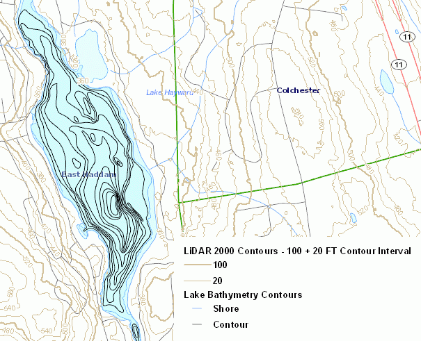
Includes Elevation Contour information for Connecticut and Lake Bathymetry (depth contours) for selected lakes and water courses.
Elevation Contours includes 2, 10, 20, 50, and 100 ft elevation contour lines for Connecticut. Note, the contour interval shown depends on the current scale of the map with smaller intervals displayed when zoomed in at larger and more detailed scales. This information was derived from Connecticut’s 2000 statewide LiDAR dataset by the University of Connecticut, College of Agriculture and Natural Resources, Department of Natural Resources and the Environment. These data are a Beta product intended for research and demonstration purposes.
Lake Bathymetry describes the water depth for selected reservoirs, lakes, ponds, and coves in Connecticut. It includes depth contours, also called bathymetric contours, that define lines of equal water depth in feet. This information was collected and compiled by the State of Connecticut, Department of Environmental Protection over a period of time using a variety of different techniques and equipment including manual depth soundings, use of an electronic depth sounder, use of a GPS receiver to locate the boat, and digitizing previously published bathymetry maps. Data is compiled at a variety of scales and resolutions, depending on the collection method used for a particular waterbody. A list of the waterbodies included in this layer can be viewed in the GIS Metadata for Lake Bathymetry. This information was used to publish bathymetric maps in the A Fisheries Guide to Lakes and Ponds of Connecticut, Robert P. Jacobs, Eileen B. O'Donnell, and William B. Gerrish, Connecticut Department of Environmental Protection Bulletin 35, 2002, SBN 0-942085-11-6.
The Elevation Contour information denotes elevation above sea level. From these contours a general sense of the lie of the land, terrain or relief can be determined. Terrain affects surface water flow. The direction of a stream can be determined by taking note of the shape of contour lines as they cross a stream. Contour lines are often V shaped where they cross a stream. Commonly known as the rule of V's, the V in the contour line always points upstream. Additionally, the closer contour lines are to one another the steeper the slope.
The Lake Bathymetry information was compiled to depict water depth and map the bottom of selected water bodies open to the public for fishing in Connecticut.
The Elevation Contour information is known to be incorrect in some areas. Please refer to the Elevation Contours CT ECO Basic Data Guide for an explanation of this use limitation.
Lake Bathymetry information is only included for the 125 waterbodies listed in the GIS Metadata. These data were collected and compiled through a variety of methods and no specific scale is recommended. There are no distribution restrictions, but the Connecticut Department of Environmental Protection should be cited on any published maps using this dataset. Due to differences in data capture dates and spatial accuracy, the Lake Bathymetry shoreline and depth contour data may not line up exactly with shoreline features in other hydrography related data from DEP such as Connecticut Hydrography, Connecticut Waterbody, Connecticut Named Waterbody and Connecticut Surface Water Quality Class.
Elevation Contours
Lake Bathymetry
This CT ECO data guide describes a thematic map that is no longer available online from CT ECO. A more recent Connectictut Elevation and Lake Bathymetry CT ECO Guide describes a similar map currently online that includes slightly different Connecticut Contours 2000 data.