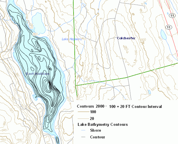
Includes Elevation Contour information for Connecticut and Lake Bathymetry (depth contours) for selected lakes and water courses.
Elevation contours shown on this map are Connecticut Contours 2000 data, which is a statewide dataset of 2, 5, 10, 20, 50, and 100 ft contour lines for Connecticut based on elevation information for the year 2000. Note, the actual contour interval shown depends on the scale of the map, with smaller intervals displayed when zoomed in and larger intervals displayed when zoomed out at less detailed scales. This information replaces the Lidar 2000 Contour data previously shown on this map.
Lake Bathymetry describes the water depth for selected reservoirs, lakes, ponds, and coves in Connecticut. It includes depth contours, also called bathymetric contours, that define lines of equal water depth in feet. This information was collected and compiled by the State of Connecticut, Department of Environmental Protection over a period of time using a variety of different techniques and equipment including manual depth soundings, use of an electronic depth sounder, use of a GPS receiver to locate the boat, and digitizing previously published bathymetry maps. Data is compiled at a variety of scales and resolutions, depending on the collection method used for a particular waterbody. A list of the waterbodies included in this layer can be viewed in the GIS Metadata for Lake Bathymetry. This information was used to publish bathymetric maps in the A Fisheries Guide to Lakes and Ponds of Connecticut, Robert P. Jacobs, Eileen B. O'Donnell, and William B. Gerrish, Connecticut Department of Environmental Protection Bulletin 35, 2002, SBN 0-942085-11-6.
The Elevation Contour information describes elevation above sea level. With this information, a general sense of the lay of the land, terrain or relief can be ascertained. Gentle sloops are characterized by widely spaced contour lines. Steep slopes are represented by closely spaced contour lines. Contour lines that cross streams flowing through valleys of noticeable relief will form a V-shaped deflection with the apex of the V pointing upstream. This is commonly known as the rule of V's.
The Lake Bathymetry information was compiled to depict water depth and map the bottom of selected water bodies open to the public for fishing in Connecticut.
The Elevation Contour information is known to be incorrect in some areas and is only suitable for general planning and informational purposes. It is not intended for exact determinations of floodplain or other similar elevations where a detailed survey is normally required, for example. It is useful in obtaining a general understanding of the elevation for a particular area, but not suitable for detailed engineering, building and design purposes. Refer to the Connecticut Contours 2000 CT ECO Basic Data Guide for additional information on the use limitations of this information.
Lake Bathymetry information is only included for the 125 waterbodies listed in the GIS Metadata. These data were collected and compiled through a variety of methods and no specific scale is recommended. There are no distribution restrictions, but the Connecticut Department of Environmental Protection should be cited on any published maps using this dataset. Due to differences in data capture dates and spatial accuracy, the Lake Bathymetry shoreline and depth contour data may not line up exactly with shoreline features in other hydrography related data from DEP such as Connecticut Hydrography, Connecticut Waterbody, Connecticut Named Waterbody and Connecticut Surface Water Quality Class.
Elevation Contours
Lake Bathymetry
This CT ECO data guide replaces the previous Elevation Contours and Lake Bathymetry data guide describing a similar, previously available thematic map that included the original Elevation Contours 2000 data.