A standardized mapping of natural drainage basins in Connecticut was completed in 1981 by the Connecticut Department of Environmental Protection (DEP). This drainage basin system divided Connecticut into 8 major basins, 45 regional basins, 337 subregional basins, 2,898 local basins, and 7,067 small drainage basin areas. The statewide mapping of natural drainage basins established a hierarchical system of basins based on drainage area size with large major basins subdivided into regional basins, regional basins subdivided into subregional basins, subregional basins subdivided into local basins, and local basins subdivided into smaller and more numerous drainage basin areas. It includes watersheds for Connecticut rivers, streams, brooks, lakes, reservoirs and ponds included on 1:24,000-scale 7.5 minute topographic quadrangle maps published by the U.S. Geological Survey (USGS) between 1969 and 1984. These basin units include smaller watersheds that drain into many of the small streams and ponds in Connecticut. These basin areas are the building blocks for the larger local, subregional, regional and major drainage basins defined by DEP.
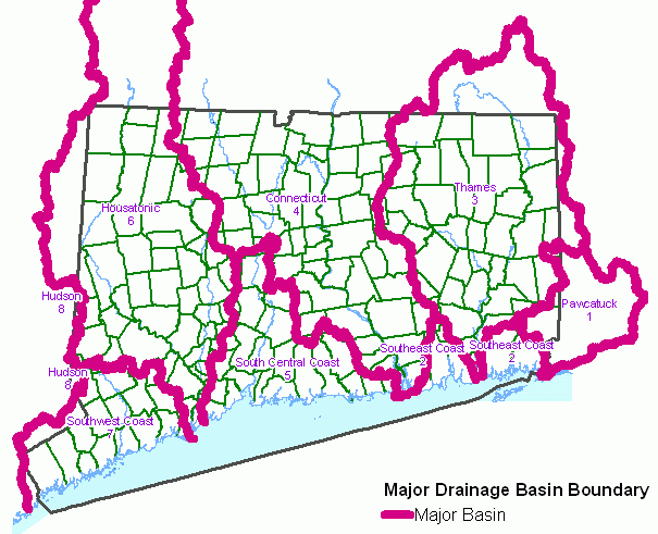
Connecticut Major Drainage Basins includes 8 major drainage basin areas for large river basins in Connecticut such as the Connecticut and Thames as well as coastal basins along the Connecticut shoreline. Each one is uniquely identified by a 1 digit major basin number (MBAS_NO) that ranges from 1 to 8. These major basin numbers include Pawcatuck River (1), Southeast Coast (2), Thames River (3), Connecticut River (4), South Central Coast (5), Housatonic River (6), Southwest Coast (7), and Hudson River (8). Note there are more major basin areas delineated (10) than unique major basin numbers (8) because two areas are necessary to represent both the entire South East Coast and Hudson Major basins in Connecticut. Refer to the Connecticut Major Drainage Basin GIS metadata for more information about drainage basin numbers.
These basin boundaries are the digital equivalent of the major drainage basin boundaries published on the 1:125,000-scale state map entitled Natural Drainage Basins in Connecticut, McElroy, 1981.
A drainage basin is an area of land where water from rain or snow melt drains downhill into a body of water such as a river, lake, wetland or ocean. The drainage basin includes both the streams and rivers that convey the water as well as the land surface from which water drains into those channels. Used as the basis for DEP drainage basin mapping, a natural drainage basin is one in which the outlet point is a natural occurring feature. These outlet points occur at stream confluences, stream outfalls into waterbodies, and impoundments.
The hierarchical system of drainage basin delineation and numbering, as implemented by DEP, allow for the association of the physical resources to the naturally occuring drainage system that covers Connecticut. This information can be used to determine where rainfall naturally flows over the land and downstream to a particular watercourse. It can be used to identify the upstream contributing watershed for a point along a river, stream, reservoir, lake, or pond. And for cataloging purposes, a drainage basin identifier can be associated with any location on land or water in Connecticut.
Drainage basin boundaries were manually delineated by interpreting the 10 foot contour lines and hydrography features shown on USGS 1:24,000-scale topographic quadrangle maps. The horizontal positional accuracy of this information is consistent with other 1:24,000-scale hydrography related data such as Connecticut Hydrography, Connecticut Waterbody, Connecticut Named Waterbody and Connecticut Surface Water Quality Classification. Only limited field checking was conducted to verify the location of these basin boundaries. Basin boundaries may not be accurate in areas that have been diked for flood control, upland wetland and reservoirs having outlets into two basins, and areas where topographic mapping is not up to date, is inaccurate, or is not detailed enough to adequately define local drainage. Residential and commercial development, highway construction, and other changes to the landscape may have resulted in local modifications to the natural drainage pattern since the time these basin boundaries were delineated.